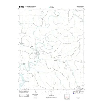
2012 Map of Galena
USGS Topo · Published 2012About this map
Galena sits at a prominent bend of the James River, serving as a focal point for this section of Stone County. The landscape is defined by the deep incisions of the river and its tributaries, creating a series of named hollows such as Sugar Tree Hollow, Coon Hollow, and Pratt Hollow. To the southwest, the waters of Table Rock Lake reach into the terrain, while the Butler Bluffs overlook the river's winding path.
Find a feature on this map
98 named features on this map. Tap any name to fly to it.
Don’t see what you’re looking for? This feature index may not catch every label — zoom into the map to look around manually.
Map Details
Editions of this 2012 Galena Map
This is the sole edition of this map. No revisions or reprints were ever made.
Other maps of this area

1907 · Forsyth
USGS Topo · 1:125,000

1927 · Shell Knob
USGS Topo · 1:62,500

1942 · Aurora
USGS Topo · 1:62,500

1945 · Harrison
USGS Topo · 1:250,000

1945 · Aurora
USGS Topo · 1:62,500

1949 · Harrison
USGS Topo · 1:250,000

1950 · Shell Knob
USGS Topo · 1:62,500

1950 · Garber
USGS Topo · 1:24,000

1954 · Harrison
USGS Topo · 1:250,000
1955 · Hurley
USGS Topo · 1:24,000