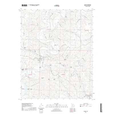
2017 Map of Galena
USGS Topo · Published 2017About this map
Galena and Reeds Spring anchor this portion of Stone County, where the topography is defined by the winding course of the James River. The river forms distinctive features such as McCord Bend and the Butler Bluffs, carving through a landscape dense with named hollows. Local family and community history is anchored by the Parsons Cem and Bass Cem, providing valuable points of reference for genealogists. To the north, Crane Creek joins the larger drainage system, while Oto Ridge provides a high-ground contrast to the deep incisions of Sugar Tree Hollow and Powder Mill Hollow. The southern portion of the map reveals the northern reaches of Table Rock Lake, illustrating how the regional hydrology transitions from free-flowing river to reservoir. A network of rural roads, including State Hwy AA and Crescent Ridge School Rd, connects these isolated valleys and ridges.
Find a feature on this map
104 named features on this map. Tap any name to fly to it.
Don’t see what you’re looking for? This feature index may not catch every label — zoom into the map to look around manually.
Map Details
Editions of this 2017 Galena Map
This is the sole edition of this map. No revisions or reprints were ever made.
Other maps of this area

1907 · Forsyth
USGS Topo · 1:125,000

1927 · Shell Knob
USGS Topo · 1:62,500

1942 · Aurora
USGS Topo · 1:62,500

1945 · Harrison
USGS Topo · 1:250,000

1945 · Aurora
USGS Topo · 1:62,500

1949 · Harrison
USGS Topo · 1:250,000

1950 · Shell Knob
USGS Topo · 1:62,500

1950 · Garber
USGS Topo · 1:24,000

1954 · Harrison
USGS Topo · 1:250,000
1955 · Hurley
USGS Topo · 1:24,000