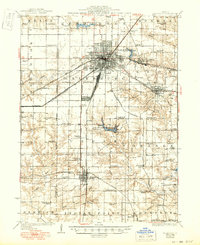
1925 Map of Galesburg
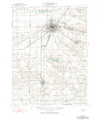
USGS Topo · Published 1984About this map
Galesburg serves as a major transportation hub in this mid-century update of a 1920s survey, where the radiating lines of the Chicago Burlington And Quincy and the Atchison Topeka And Santa Fe railroads define the local economy. The landscape is dotted with a dense network of country schoolhouses, including uniquely named sites like Cornfield College School and Stringtown School, indicating the agricultural vitality of Knox and Warren counties. Recreation and community life appear centered around Lake Bracken, the Knox County Country Club, and Camp Shaubena. Further south, the map details the growing industrial and residential layout of Abingdon, while rural life remains anchored by local landmarks like Haynes Church and the Orange Chapel. This document reveals the transition from early 20th-century rail reliance to the expanding infrastructure of post-war Illinois.
Find a feature on this map
75 named features on this map. Tap any name to fly to it.
Don’t see what you’re looking for? This feature index may not catch every label — zoom into the map to look around manually.
Map Details
Editions of this 1925 Galesburg Map
2 editions found

Historical Maps of Galesburg Through Time
4 maps found