Loading...
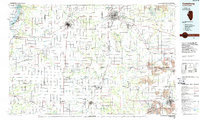
Loading map...1985 Map of Galesburg
USGS Topo · Published 1988About this map
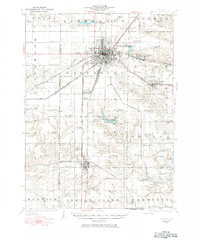
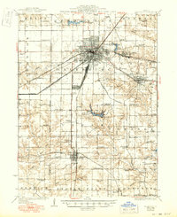
Galesburg and Monmouth serve as the primary hubs for this Western Illinois region, which is defined by a dense network of major railroads including the Burlington Northern and the Atchison Topeka and Santa Fe. The landscape transitions from the agricultural heartland around Knoxville and Abingdon to the western edge where the Mississippi River creates a diverse wetland environment preserved in the Big River State Forest and the Oquawka State Wildlife Refuge.
Find a feature on this map
103 named features on this map. Tap any name to fly to it.
Don’t see what you’re looking for? This feature index may not catch every label — zoom into the map to look around manually.
Map Details
Date Portrayed1985
Date Published1988
PublisherU.S. Geological Survey
Map TypeTopographic
Scale1:100,000
Physical Dimensions40.2 x 24.1 inches
Editions of this 1985 Galesburg Map
2 editions found

Historical Maps of Galesburg Through Time
4 maps found

Featured Locations
Source Details
SourceU.S. Geological Survey
CopyrightPublic Domain