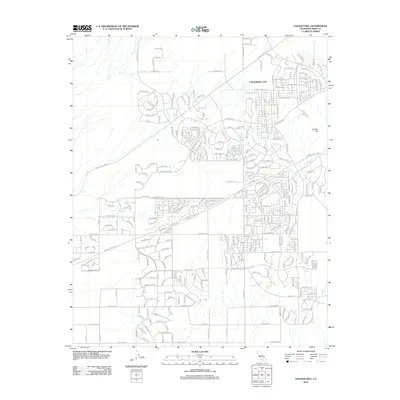
2012 Map of Galileo Hill
USGS Topo · Published 2012About this map
California City spreads across this high desert landscape, characterized by its ambitious and expansive street network that reaches deep into the arid terrain. The layout reveals an intricate grid of residential planning, where thoroughfares like Kennedy Blvd and Santa Clara St connect diverse neighborhoods ranging from the developed core to outlying desert tracts. Dominating the eastern portion of the sheet is the distinctive rise of Galileo Hill, which provides a natural anchor to the otherwise structured grid. The map also traces major regional arteries such as the Randsburg Mojave Rd, which cuts diagonally across the western sections, linking this modern development with the historic desert routes of Kern County. Local streets carry evocative names like Matterhorn Dr and San Marcos Dr, illustrating the planned character of this community in the early twenty-first century.
Find a feature on this map
277 named features on this map. Tap any name to fly to it.
Don’t see what you’re looking for? This feature index may not catch every label — zoom into the map to look around manually.
Map Details
Editions of this 2012 Galileo Hill Map
This is the sole edition of this map. No revisions or reprints were ever made.
Other maps of this area

1903 · Randsburg
USGS Topo · 1:62,500

1911 · Randsburg
USGS Topo · 1:62,500

1912 · Randsburg
USGS Topo · 1:62,500

1915 · Searles Lake
USGS Topo · 1:250,000

1943 · Saltdale
USGS Topo · 1:62,500

1943 · Castle Butte
USGS Topo · 1:62,500

1947 · Castle Butte
USGS Topo · 1:50,000

1947 · Desert Butte
USGS Topo · 1:24,000
1947 · Castle Butte SE
USGS Topo · 1:24,000

1947 · Johannesburg SW
USGS Topo · 1:24,000