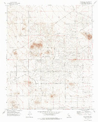
1973 Map of Galileo Hill
USGS Topo · Published 1976About this map
California City appears in the early 1970s as an ambitious grid of planned streets and boulevards etched into the high desert landscape. The layout is defined by long, sweeping thoroughfares such as California City Blvd and Borax Bill Parkway, which cut through the desert scrub to connect distant residential sections and local landmarks like Galileo Park. This survey illustrates a unique moment in the city's development, where the optimistic geometry of the street plan often outpaces the built environment.
Find a feature on this map
23 named features on this map. Tap any name to fly to it.
Don’t see what you’re looking for? This feature index may not catch every label — zoom into the map to look around manually.
Map Details
Editions of this 1973 Galileo Hill Map
This is the sole edition of this map. No revisions or reprints were ever made.
Other maps of this area

1903 · Randsburg
USGS Topo · 1:62,500

1911 · Randsburg
USGS Topo · 1:62,500

1912 · Randsburg
USGS Topo · 1:62,500

1915 · Searles Lake
USGS Topo · 1:250,000

1943 · Saltdale
USGS Topo · 1:62,500

1943 · Castle Butte
USGS Topo · 1:62,500

1947 · Castle Butte
USGS Topo · 1:50,000

1947 · Desert Butte
USGS Topo · 1:24,000
1947 · Castle Butte SE
USGS Topo · 1:24,000

1947 · Johannesburg SW
USGS Topo · 1:24,000