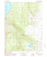
1989 Map of Gallatin Peak
USGS Topo · Published 1989About this map
Eagle Lake dominates the northwestern edge of this landscape, its waters meeting the shore at Miners Bay and Eagles Nest. This 1980s survey captures a transition between the academic and recreational use of the lake at the Eagle Lake Field Station (CSU-Chico) and the Lassen County Youth Camp. The terrain rises sharply from the water toward the heights of Black Mountain and Gallatin Peak, where the timbered slopes of the Lassen National Forest are marked by the Burn area and high-elevation waters like Mahogany Lake.
Find a feature on this map
33 named features on this map. Tap any name to fly to it.
Don’t see what you’re looking for? This feature index may not catch every label — zoom into the map to look around manually.
Map Details
Editions of this 1989 Gallatin Peak Map
This is the sole edition of this map. No revisions or reprints were ever made.
Other maps of this area

1886 · Honey Lake
USGS Topo · 1:250,000

1891 · Honey Lake
USGS Topo · 1:250,000

1893 · Honey Lake
USGS Topo · 1:250,000

1954 · Susanville
USGS Topo · 1:62,500

1954 · Fredonyer Peak
USGS Topo · 1:62,500

1955 · Westwood
USGS Topo · 1:62,500

1955 · Westwood
USGS Topo · 1:250,000

1956 · Antelope Mtn
USGS Topo · 1:62,500

1958 · Westwood
USGS Topo · 1:250,000

1959 · Westwood
USGS Topo · 1:250,000