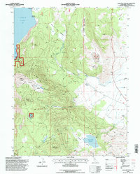
1995 Map of Gallatin Peak
USGS Topo · Published 1998About this map
Eagle Lake dominates the northwest corner of this mid-1990s survey, its shoreline housing the Eagle Lake Field Station and the Lassen County Youth Camp. The landscape transitions from the high peaks of the Lassen National Forest toward the cattle-ranching territory of Willow Creek Valley. Land use here is defined by a mix of forestry, research, and agriculture, evidenced by Murrers Ranch and Five Dot Ranch at the valley floor. Water management remains central to the region, with flume and canal systems drawing from high-altitude sources like Summit Lake and the Round Valley Reservoir. Researchers can trace old mining footprints at the Adit Mine Dump or find secluded landmarks like Mahogany Lake and a lone Grave near Murrers Ranch, markers of the rugged history of Lassen County.
Find a feature on this map
43 named features on this map. Tap any name to fly to it.
Don’t see what you’re looking for? This feature index may not catch every label — zoom into the map to look around manually.
Map Details
Editions of this 1995 Gallatin Peak Map
This is the sole edition of this map. No revisions or reprints were ever made.
Other maps of this area

1886 · Honey Lake
USGS Topo · 1:250,000

1891 · Honey Lake
USGS Topo · 1:250,000

1893 · Honey Lake
USGS Topo · 1:250,000

1954 · Susanville
USGS Topo · 1:62,500

1954 · Fredonyer Peak
USGS Topo · 1:62,500

1955 · Westwood
USGS Topo · 1:62,500

1955 · Westwood
USGS Topo · 1:250,000

1956 · Antelope Mtn
USGS Topo · 1:62,500

1958 · Westwood
USGS Topo · 1:250,000

1959 · Westwood
USGS Topo · 1:250,000