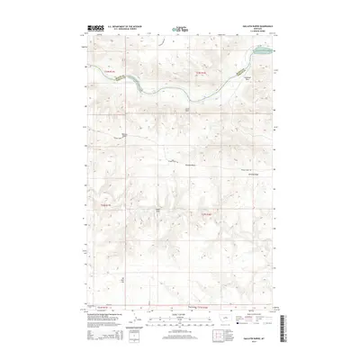
2014 Map of Gallatin Rapids
USGS Topo · Published 2014About this map
The Missouri River carves a critical boundary between Blaine and Fergus counties, marked by turbulent river features including Gallatin Rapids, Bear Rapids, and Little Dog Rapids. This northern Montana landscape is defined by its dramatic relief and sparse infrastructure, where the river's path is constrained by landmarks such as Sugarloaf Rock and Leslie Point. The terrain rising from the river breaks into complex drainage patterns like Flax Coulee and the winding Dog Cr. High ground dominates the southern half of the quadrangle, notably along Whiskey Ridge and Jones Cone. A legacy of resource exploration is visible at Oil Well Hill, while the remote character of the region is preserved through limited access points like Ragland Ridge Rd and the Pn Bridge Rd near the southern map margin.
Find a feature on this map
23 named features on this map. Tap any name to fly to it.
Don’t see what you’re looking for? This feature index may not catch every label — zoom into the map to look around manually.
Map Details
Editions of this 2014 Gallatin Rapids Map
This is the sole edition of this map. No revisions or reprints were ever made.
Other maps of this area

1954 · Taffy Ridge
USGS Topo · 1:24,000

1954 · Leroy
USGS Topo · 1:24,000

1954 · Gallatin Rapids
USGS Topo · 1:24,000

1954 · Council Island
USGS Topo · 1:24,000

1954 · Lewistown
USGS Topo · 1:250,000

1959 · Lewistown
USGS Topo · 1:250,000

1964 · Anderson Bridge
USGS Topo · 1:24,000

1964 · Ragland Bench
USGS Topo · 1:24,000

1964 · Chase Hill
USGS Topo · 1:24,000
1985 · Winifred East
USGS Topo · 1:24,000