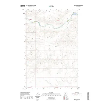
2020 Map of Gallatin Rapids
USGS Topo · Published 2020About this map
The Missouri River cuts a deep and winding path through the borderlands of Blaine and Fergus counties, where it is defined by a series of significant whitewater obstacles. This stretch of the river is characterized by the Gallatin Rapids, Bear Rapids, and Little Dog Rapids, which shaped early navigation and travel through this part of Montana. The surrounding terrain is a complex network of ridges and drainages, marked by distinctive high points like Sugarloaf Rock and Jones Cone.
Find a feature on this map
21 named features on this map. Tap any name to fly to it.
Don’t see what you’re looking for? This feature index may not catch every label — zoom into the map to look around manually.
Map Details
Editions of this 2020 Gallatin Rapids Map
This is the sole edition of this map. No revisions or reprints were ever made.
Other maps of this area

1954 · Taffy Ridge
USGS Topo · 1:24,000

1954 · Leroy
USGS Topo · 1:24,000

1954 · Gallatin Rapids
USGS Topo · 1:24,000

1954 · Council Island
USGS Topo · 1:24,000

1954 · Lewistown
USGS Topo · 1:250,000

1959 · Lewistown
USGS Topo · 1:250,000

1964 · Anderson Bridge
USGS Topo · 1:24,000

1964 · Ragland Bench
USGS Topo · 1:24,000

1964 · Chase Hill
USGS Topo · 1:24,000
1985 · Winifred East
USGS Topo · 1:24,000