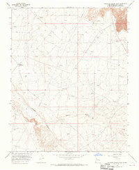
1965 Map of Gallegos Trading Post
USGS Topo · Published 1969About this map
Gallegos Trading Post stands as a focal point in this high desert landscape of San Juan County, where the infrastructure of the mid-century energy industry intersects with older ranching traditions. The terrain is defined by the deep incisions of Gallegos Canyon and Cedar Canyon, providing a stark contrast to the plateau. The 1965 survey reveals an extensive network of pipelines, numerous gas wells, and scattered drill holes, illustrating the rapid expansion of resource extraction in the San Juan Basin. Amidst this industrial growth, legacy landmarks such as the Gallegos Windmill, McKay Windmill, and Pete Spring mark the essential water points that sustained life in this arid environment long before the arrival of the Pumping Sta.
Find a feature on this map
13 named features on this map. Tap any name to fly to it.
Don’t see what you’re looking for? This feature index may not catch every label — zoom into the map to look around manually.
Map Details
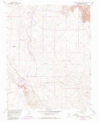
Editions of this 1965 Gallegos Trading Post Map
2 editions found
Other maps of this area

1889 · Largo
USGS Topo · 1:250,000

1889 · Chaco
USGS Topo · 1:250,000

1892 · Chaco
USGS Topo · 1:250,000

1895 · Largo
USGS Topo · 1:250,000

1954 · Shiprock
USGS Topo · 1:250,000

1954 · Aztec
USGS Topo · 1:250,000

1958 · Shiprock
USGS Topo · 1:250,000

1958 · Aztec
USGS Topo · 1:250,000

1959 · Shiprock
USGS Topo · 1:250,000

1960 · Bloomfield
USGS Topo · 1:62,500
Featured Places
- Eastern Navajo Agency, NM
- Huerfano, Eastern Navajo Agency
- Teeł Sikaad, Eastern Navajo Agency
- San Juan County, NM
- United States