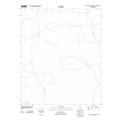
2010 Map of Gallo Spring Canyon NE
USGS Topo · Published 2010About this map
Cola del Gallo Arroyo snakes across this high desert landscape in Lincoln County, defining the drainage patterns of a region primarily dedicated to ranching and livestock. The 2010 survey highlights isolated outposts of local habitation, most notably Nalda Ranch in the north and the settlement of Hiner along the main waterway. These sites, along with the Red Windmill, underscore the essential infrastructure required for survival in this arid environment. The map details a network of unpaved tracks and local routes, such as County Rd B041, which link these remote points of interest. Topographic features including Gallo Canyon and North Canyon provide further geographical context for researchers examining the distribution of water and human presence in this part of New Mexico.
Find a feature on this map
7 named features on this map. Tap any name to fly to it.
Don’t see what you’re looking for? This feature index may not catch every label — zoom into the map to look around manually.
Map Details
Editions of this 2010 Gallo Spring Canyon NE Map
This is the sole edition of this map. No revisions or reprints were ever made.
Other maps of this area

1954 · Fort Sumner
USGS Topo · 1:250,000

1958 · Fort Sumner
USGS Topo · 1:250,000

1980 · Corona
USGS Topo · 1:100,000

1981 · Gallo Spring Canyon
USGS Topo · 1:24,000

1981 · Gacho Hill SW
USGS Topo · 1:24,000

1981 · Camaleon Draw West
USGS Topo · 1:24,000

1981 · Camaleon Draw East
USGS Topo · 1:24,000

1981 · Cowboy Mesa SW
USGS Topo · 1:24,000
1981 · Cowboy Mesa NW
USGS Topo · 1:24,000
1981 · Red Bluff Draw East
USGS Topo · 1:24,000