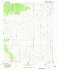
1981 Map of Cowboy Mesa NW
USGS Topo · Published 1981About this map
Arroyo del Gallo carves through the southwestern portion of this landscape, marking the dominant drainage pattern in a region defined by its water-scarcity features. This 1981 survey of the high desert terrain in Lincoln County captures a sparse network of ranching infrastructure and hydrological markers. Named points of interest are few, but significant for understanding local water management and land use, including Middle Well in the northeast and a lone Tank situated in the north-central flats. The map provides a precise look at the township boundaries between T 1 S and T 2 S, reflecting the grid-based surveying that organized the settlement of the New Mexico interior. For those researching the history of land allotments or early ranching routes, these specific water sources and boundary lines serve as critical landmarks in a primarily open landscape.
Find a feature on this map
4 named features on this map. Tap any name to fly to it.
Don’t see what you’re looking for? This feature index may not catch every label — zoom into the map to look around manually.
Map Details
Editions of this 1981 Cowboy Mesa NW Map
This is the sole edition of this map. No revisions or reprints were ever made.
Other maps of this area

1954 · Fort Sumner
USGS Topo · 1:250,000

1958 · Fort Sumner
USGS Topo · 1:250,000

1980 · Corona
USGS Topo · 1:100,000

1981 · Cowboy Mesa NE
USGS Topo · 1:24,000

1981 · Gacho Hill SW
USGS Topo · 1:24,000

1981 · Camaleon Draw East
USGS Topo · 1:24,000

1981 · Cowboy Mesa SW
USGS Topo · 1:24,000
1981 · Cowboy Mesa
USGS Topo · 1:24,000

1981 · Gacho Hill SE
USGS Topo · 1:24,000
1981 · Red Bluff Draw East
USGS Topo · 1:24,000