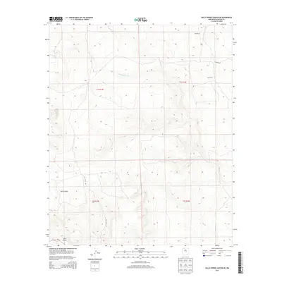
2013 Map of Gallo Spring Canyon NE
USGS Topo · Published 2013About this map
Nalda Ranch and the small settlement of Hiner define the sparsely populated character of this high-desert landscape in Lincoln County. The map details a complex network of arroyos and canyons that channel seasonal waters through the terrain, most notably the Cola del Gallo Arroyo and the deep cuts of North Canyon and Gallo Canyon. Transportation in this area relies on unpaved routes like Red Canyon Rd and Co Road B041, which connect remote ranching outposts to Nm-247 in the southwest corner. The presence of the Red Windmill indicates the critical importance of water infrastructure in this arid region, providing a specific landmark for local history researchers tracing the development of land use and livestock management in the early 21st century.
Find a feature on this map
13 named features on this map. Tap any name to fly to it.
Don’t see what you’re looking for? This feature index may not catch every label — zoom into the map to look around manually.
Map Details
Editions of this 2013 Gallo Spring Canyon NE Map
This is the sole edition of this map. No revisions or reprints were ever made.
Other maps of this area

1954 · Fort Sumner
USGS Topo · 1:250,000

1958 · Fort Sumner
USGS Topo · 1:250,000

1980 · Corona
USGS Topo · 1:100,000

1981 · Gallo Spring Canyon
USGS Topo · 1:24,000

1981 · Gacho Hill SW
USGS Topo · 1:24,000

1981 · Camaleon Draw West
USGS Topo · 1:24,000

1981 · Camaleon Draw East
USGS Topo · 1:24,000

1981 · Cowboy Mesa SW
USGS Topo · 1:24,000
1981 · Cowboy Mesa NW
USGS Topo · 1:24,000
1981 · Red Bluff Draw East
USGS Topo · 1:24,000