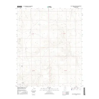
2017 Map of Gallo Spring Canyon NE
USGS Topo · Published 2017About this map
Cola del Gallo Arroyo winds through this high-altitude landscape in northern Lincoln County, where the terrain is defined by deep drainage systems and established land partitions. The area is marked by significant topographical relief, notably at Gallo Canyon in the southwest and North Canyon further north. This portion of New Mexico is structured by the Public Land Survey System, with the intersections of t1s r15e, t1s r16e, t2s r15e, and t2s r16e clearly delineated. Access into this high-desert territory is facilitated by Red Canyon Rd, which cuts through the western sections of the map, providing a glimpse into the remote transportation network used by local ranchers and land managers in the 21st century.
Find a feature on this map
8 named features on this map. Tap any name to fly to it.
Don’t see what you’re looking for? This feature index may not catch every label — zoom into the map to look around manually.
Map Details
Editions of this 2017 Gallo Spring Canyon NE Map
This is the sole edition of this map. No revisions or reprints were ever made.
Other maps of this area

1954 · Fort Sumner
USGS Topo · 1:250,000

1958 · Fort Sumner
USGS Topo · 1:250,000

1980 · Corona
USGS Topo · 1:100,000

1981 · Gallo Spring Canyon
USGS Topo · 1:24,000

1981 · Gacho Hill SW
USGS Topo · 1:24,000

1981 · Camaleon Draw West
USGS Topo · 1:24,000

1981 · Camaleon Draw East
USGS Topo · 1:24,000

1981 · Cowboy Mesa SW
USGS Topo · 1:24,000
1981 · Cowboy Mesa NW
USGS Topo · 1:24,000
1981 · Red Bluff Draw East
USGS Topo · 1:24,000