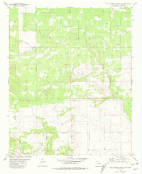
1981 Map of Gallo Spring Canyon NE
USGS Topo · Published 1981About this map
Gallo del Arroyo snakes through this high-altitude landscape of Lincoln County, defining the drainage patterns of a region shaped by intermittent water and sparse ranching infrastructure. This 1981 survey reveals a landscape where survival depends on distributed resources like the Pine Draw Well and the Red Windmill, isolated markers of human presence in a vast terrain of canyons and draws. The southern portion of the quadrangle is deeply incised by the drainage of Gallo Canyon and North Canyon, which converge near a labeled point simply known as Spanish. An aviation element is visible on the western edge, where a dual-path Landing Strip is carved into the plateau, suggesting the remote nature of the area and the reliance on air travel for access or land management in the late 20th century.
Find a feature on this map
7 named features on this map. Tap any name to fly to it.
Don’t see what you’re looking for? This feature index may not catch every label — zoom into the map to look around manually.
Map Details
Editions of this 1981 Gallo Spring Canyon NE Map
This is the sole edition of this map. No revisions or reprints were ever made.
Other maps of this area

1954 · Fort Sumner
USGS Topo · 1:250,000

1958 · Fort Sumner
USGS Topo · 1:250,000

1980 · Corona
USGS Topo · 1:100,000

1981 · Gallo Spring Canyon
USGS Topo · 1:24,000

1981 · Gacho Hill SW
USGS Topo · 1:24,000

1981 · Camaleon Draw West
USGS Topo · 1:24,000

1981 · Camaleon Draw East
USGS Topo · 1:24,000

1981 · Cowboy Mesa SW
USGS Topo · 1:24,000
1981 · Cowboy Mesa NW
USGS Topo · 1:24,000
1981 · Red Bluff Draw East
USGS Topo · 1:24,000