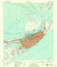
1954 Map of Galveston
USGS Topo · Published 1958About this map
Galveston and the Bolivar Peninsula meet at the deep-water passage of Bolivar Roads, where the mid-century city serves as a critical maritime and rail hub. The coastal defense network is prominent, featuring Fort Crockett, Fort San Jacinto, and Fort Travis guarding the harbor entrance. On the island, a dense grid of schools and hospitals, including the University of Texas Medical College and St Marys Hospital, underscores the city's role as a regional center for education and health. Marine traffic moves through the Houston Ship Channel and the Intracoastal Waterway, while terrestrial transport is anchored by Union Station and the Galveston Houston and Henderson Railroad. On the peninsula, an abandoned lighthouse stands near the State Hy 87 Ferry landing, marking the transition from the bustling city to the more sparsely settled Port Bolivar.
Find a feature on this map
62 named features on this map. Tap any name to fly to it.
Don’t see what you’re looking for? This feature index may not catch every label — zoom into the map to look around manually.
Map Details
Editions of this 1954 Galveston Map
4 editions found
Other maps of this area

1929 · Virginia Point
USGS Topo · 1:24,000

1929 · Texas City
USGS Topo · 1:24,000

1930 · Galveston
USGS Topo · 1:24,000

1931 · Lake Como
USGS Topo · 1:24,000

1931 · Flake
USGS Topo · 1:24,000

1932 · Texas City
USGS Topo · 1:31,680

1932 · Bolivar Point
USGS Topo · 1:24,000

1932 · Virginia Point
USGS Topo · 1:31,680

1933 · The Jetties
USGS Topo · 1:31,680

1933 · Bolivar Point
USGS Topo · 1:31,680