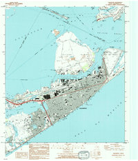
1994 Map of Galveston
USGS Topo · Published 1994About this map
Galveston Island and the Bolivar Peninsula dominate this coastal landscape, separated by the deep waters of Bolivar Roads. The dense urban grid of Galveston is meticulously detailed, showing the concentration of civic and educational institutions like the University of Texas Medical Branch and Ball High School. The northern shoreline is defined by heavy maritime infrastructure, including the piers along the Galveston Channel and the expansive Pelican Island, which hosts Texas A & M University at Galveston.
Find a feature on this map
71 named features on this map. Tap any name to fly to it.
Don’t see what you’re looking for? This feature index may not catch every label — zoom into the map to look around manually.
Map Details
Editions of this 1994 Galveston Map
This is the sole edition of this map. No revisions or reprints were ever made.
Other maps of this area

1929 · Virginia Point
USGS Topo · 1:24,000

1929 · Texas City
USGS Topo · 1:24,000

1930 · Galveston
USGS Topo · 1:24,000

1931 · Lake Como
USGS Topo · 1:24,000

1931 · Flake
USGS Topo · 1:24,000

1932 · Texas City
USGS Topo · 1:31,680

1932 · Bolivar Point
USGS Topo · 1:24,000

1932 · Virginia Point
USGS Topo · 1:31,680

1933 · The Jetties
USGS Topo · 1:31,680

1933 · Bolivar Point
USGS Topo · 1:31,680