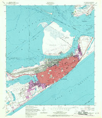
1954 Map of Galveston
USGS Topo · Published 1970About this map
Galveston is depicted as a dense urban and maritime hub, defined by its extensive waterfront infrastructure and military presence during the mid-20th century. The city's northern docks and the Intra-Coastal Waterway highlight its industrial character, while the grid of the city is punctuated by numerous educational and civic landmarks such as Ball High Sch, the Courthouse, and the University of Texas Medical College. Defense installations like Fort Crockett, Old Fort San Jacinto, and Fort Travis on the Bolivar Peninsula command the entrance to the bay, underscoring the strategic importance of this coastal point. On the Gulf side, the iconic Seawall protects the urban core from the open sea. Revision layers added in the late 1960s show the expansion of the Municipal Airport and suburban growth near Offatt Bayou, illustrating the city's transition as it grew beyond its traditional nineteenth-century boundaries.
Find a feature on this map
60 named features on this map. Tap any name to fly to it.
Don’t see what you’re looking for? This feature index may not catch every label — zoom into the map to look around manually.
Map Details
Editions of this 1954 Galveston Map
4 editions found
Other maps of this area

1929 · Virginia Point
USGS Topo · 1:24,000

1929 · Texas City
USGS Topo · 1:24,000

1930 · Galveston
USGS Topo · 1:24,000

1931 · Lake Como
USGS Topo · 1:24,000

1931 · Flake
USGS Topo · 1:24,000

1932 · Texas City
USGS Topo · 1:31,680

1932 · Bolivar Point
USGS Topo · 1:24,000

1932 · Virginia Point
USGS Topo · 1:31,680

1933 · The Jetties
USGS Topo · 1:31,680

1933 · Bolivar Point
USGS Topo · 1:31,680