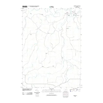
2010 Map of Garber
USGS Topo · Published 2010About this map
The Turkey River and Volga River converge in the northeastern corner of this Clayton County landscape, where the neighboring settlements of Garber and Elkport sit at the water's edge. This area is characterized by a high concentration of historic burial grounds, serving as a primary resource for genealogical research. Notable sites include Saint Michaels Cemetery, Immanuel Lutheran Cemetery, and Mount Harmony Cemetery, which are distributed along the upland ridges and valley slopes. The map also records the rural locality of Wood in the south. A complex network of creeks, such as Wolf Creek and Elk Creek, dissects the terrain, while landmarks like the Garber Bridge and the Garber Post Office anchor the local community infrastructure.
Find a feature on this map
52 named features on this map. Tap any name to fly to it.
Don’t see what you’re looking for? This feature index may not catch every label — zoom into the map to look around manually.
Map Details
Editions of this 2010 Garber Map
This is the sole edition of this map. No revisions or reprints were ever made.
Other maps of this area

1902 · Elkader
USGS Topo · 1:125,000

1957 · Colesburg
USGS Topo · 1:24,000

1959 · Dubuque
USGS Topo · 1:250,000

1961 · Dubuque
USGS Topo · 1:250,000

1962 · Dubuque
USGS Topo · 1:250,000
1962 · Garnavillo
USGS Topo · 1:24,000

1962 · Petersburg
USGS Topo · 1:24,000
1964 · Littleport
USGS Topo · 1:24,000

1964 · Edgewood
USGS Topo · 1:24,000

1964 · Garber
USGS Topo · 1:24,000