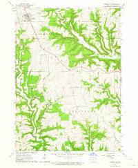
1962 Map of Garnavillo
USGS Topo · Published 1964About this map
Garnavillo serves as the primary hub of this Clayton County landscape, characterized by its alignment with the section lines and proximity to the Volga River in the southwest. The terrain is deeply incised by a network of drainage systems including Buck Creek, Miners Creek, and numerous family-named landmarks like Andy Hollow and Tuecke Hollow. The map reveals a high concentration of religious and community burial grounds, such as St Joseph Cem, St Michael Cem, and St Pauls Cem, which are scattered among the townships of Garnavillo, Clayton, and Jefferson. Small-scale industrial activity is evidenced by several Quarry sites throughout the area, while the tiny settlement of Ceres marks a notable crossroads. This survey captures the rural character of Iowa's driftless-style topography, where farmsteads and field boundaries follow the high ridges between wooded hollows like Butternut Hollow and Louse Hollow.
Find a feature on this map
30 named features on this map. Tap any name to fly to it.
Don’t see what you’re looking for? This feature index may not catch every label — zoom into the map to look around manually.
Map Details
Editions of this 1962 Garnavillo Map
This is the sole edition of this map. No revisions or reprints were ever made.
Other maps of this area

1902 · Elkader
USGS Topo · 1:125,000

1957 · Turkey River
USGS Topo · 1:24,000

1957 · Colesburg
USGS Topo · 1:24,000

1959 · Dubuque
USGS Topo · 1:250,000

1961 · Dubuque
USGS Topo · 1:250,000

1962 · Dubuque
USGS Topo · 1:250,000

1962 · Clayton
USGS Topo · 1:24,000
1962 · Bagley
USGS Topo · 1:24,000
1962 · Guttenberg
USGS Topo · 1:24,000
1964 · Littleport
USGS Topo · 1:24,000