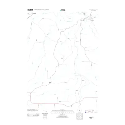
2013 Map of Garber
USGS Topo · Published 2013About this map
Elkport and Garber sit at a notable bend in the Turkey River, where the Volga River joins the flow in northeastern Iowa. This 2013 survey captures the area at a time when these small riverside communities remain connected by landmarks like the Garber Bridge and the adjacent Garber Bridge Access. The landscape is defined by a dense network of watercourses, including Bear Cr, Wolf Cr, and Steeles Br, which carve through the terrain and dictate the path of local roads like Hawk Ave and Glacier Rd. The small settlement of Littleport is situated in the northwest along the Volga, while Wood serves as a named point in the southwestern interior. This map is particularly useful for understanding the modern rural road network and the persistence of these small river towns in the face of the region's complex drainage patterns.
Find a feature on this map
75 named features on this map. Tap any name to fly to it.
Don’t see what you’re looking for? This feature index may not catch every label — zoom into the map to look around manually.
Map Details
Editions of this 2013 Garber Map
This is the sole edition of this map. No revisions or reprints were ever made.
Other maps of this area

1902 · Elkader
USGS Topo · 1:125,000

1957 · Colesburg
USGS Topo · 1:24,000

1959 · Dubuque
USGS Topo · 1:250,000

1961 · Dubuque
USGS Topo · 1:250,000

1962 · Dubuque
USGS Topo · 1:250,000
1962 · Garnavillo
USGS Topo · 1:24,000

1962 · Petersburg
USGS Topo · 1:24,000
1964 · Littleport
USGS Topo · 1:24,000

1964 · Edgewood
USGS Topo · 1:24,000

1964 · Garber
USGS Topo · 1:24,000