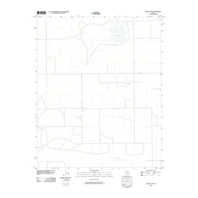
2010 Map of Garcia Lake
USGS Topo · Published 2010About this map
Garcia Lake and the drainage of Tierra Blanca Creek define this high plains landscape in Deaf Smith County. The terrain is characterized by a sparse, geometric network of rural infrastructure, where isolated water features provided critical landmarks for early ranching and travel. A system of county roads, including Co RD V and Co RD U, segments the territory into large agricultural blocks typical of the Texas Panhandle. The presence of FM 1058 serves as a primary east-west corridor through the region. This 2010 survey by the U.S. Geological Survey preserves the exact layout of the plains before further modern development, highlighting the relationship between the natural topography of the creek beds and the rigid human-made grid of the county road system.
Find a feature on this map
10 named features on this map. Tap any name to fly to it.
Don’t see what you’re looking for? This feature index may not catch every label — zoom into the map to look around manually.
Map Details
Editions of this 2010 Garcia Lake Map
This is the sole edition of this map. No revisions or reprints were ever made.
Other maps of this area

1954 · Clovis
USGS Topo · 1:250,000

1957 · Pleasant Hill
USGS Topo · 1:62,500

1958 · Clovis
USGS Topo · 1:250,000

1965 · Twin Lakes
USGS Topo · 1:24,000

1965 · Rhea
USGS Topo · 1:24,000

1971 · Mustang Lake
USGS Topo · 1:24,000

1971 · Bootleg
USGS Topo · 1:24,000

1971 · Garcia Lake
USGS Topo · 1:24,000
1971 · Walcott
USGS Topo · 1:24,000

1971 · Bellview
USGS Topo · 1:24,000