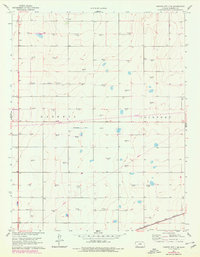
1960 Map of Garden City 3 SE
USGS Topo · Published 1978About this map
Haskell and Lockport townships define this section of the High Plains, where the agricultural landscape is heavily marked by energy infrastructure. Numerous sites for Gas Wells and an occasional Oil Well dot the section lines, connected by an extensive network of Pipelines and a primary Pipeline corridor. The central portion of the map features an Abandoned Canal, a silent witness to early irrigation efforts in this arid region. Near the western edge, the Haskell Cem provides a specific point of interest for genealogists researching early families in the county. The southern reaches are traversed by the Atchison Topeka and Santa Fe railroad, which served as the vital transportation link for the grain and livestock economy of the late 1950s and early 1960s.
Find a feature on this map
9 named features on this map. Tap any name to fly to it.
Don’t see what you’re looking for? This feature index may not catch every label — zoom into the map to look around manually.
Map Details
Editions of this 1960 Garden City 3 SE Map
3 editions found
Other maps of this area

1896 · Garden
USGS Topo · 1:125,000

1955 · Dodge City
USGS Topo · 1:250,000

1958 · Dodge City
USGS Topo · 1:250,000

1959 · Dodge City
USGS Topo · 1:250,000

1959 · Garden City 3 NW
USGS Topo · 1:24,000

1959 · Garden City 3 NE
USGS Topo · 1:24,000

1960 · Garden City 3 SW
USGS Topo · 1:24,000

1960 · Garden City 3 SE
USGS Topo · 1:24,000

1968 · Plains NW
USGS Topo · 1:24,000
1968 · Satanta
USGS Topo · 1:24,000