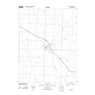
2011 Map of Garden City
USGS Topo · Published 2011About this map
Garden City serves as the central hub of this Cass County landscape, situated where Old Highway 7 and modern transit routes converge. The surrounding agricultural terrain is deeply etched by a network of waterways, including Panther Creek, Sugar Creek, and Walnut Creek, which define the local drainage patterns. This map reveals a community structured by its rural institutions, with several legacy education sites such as the Sugar Creek School, Wallace School, and Number Eight School distributed across the township. For those researching local family history, the survey identifies numerous burial grounds including Clearfork Cemetery to the north and Byler Cemetery near the southern boundary. The local economy and infrastructure are further represented by the Breed Ranch Airport and the Garden City Wastewater Treatment Facility, showing how the town managed its modern services while maintaining its traditional rural character.
Find a feature on this map
50 named features on this map. Tap any name to fly to it.
Don’t see what you’re looking for? This feature index may not catch every label — zoom into the map to look around manually.
Map Details
Editions of this 2011 Garden City Map
This is the sole edition of this map. No revisions or reprints were ever made.
Other maps of this area

1887 · Harrisonville
USGS Topo · 1:125,000

1887 · Butler
USGS Topo · 1:125,000

1892 · Harrisonville
USGS Topo · 1:125,000

1894 · Harrisonville
USGS Topo · 1:125,000

1894 · Butler
USGS Topo · 1:125,000

1947 · Lawrence
USGS Topo · 1:250,000

1950 · Lawrence
USGS Topo · 1:250,000
1953 · Creighton
USGS Topo · 1:24,000

1954 · Harrisonville
USGS Topo · 1:24,000
1954 · East Lynne
USGS Topo · 1:24,000