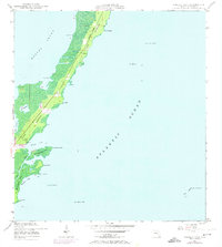
1947 Map of Garden Cove
USGS Topo · Published 1970About this map
Key Largo presents a narrow, winding profile in this mid-century topographic study, which captures the archipelago before the full surge of modern coastal development. Small settlement clusters such as Garden Cove, Mary, and Knowlson are concentrated along the central ridge, while the surrounding landscape is defined by the shallow expanse of Barnes Sound and the open Atlantic Ocean. The interior geography reveals a complex network of brackish water bodies, including Lake Surprise and Lake Simmons, separated by the Basin Hills. Farther south, the environment shifts toward the intricate shoreline of El Radabob Key and Whitmore Bight. Navigational markers like Elbow Reef Beacon B and Key Largo Beacon No 29 emphasize the importance of maritime transit to this coastal corridor, while aerial photorevisions from the late sixties illustrate the early expansion of local infrastructure.
Find a feature on this map
40 named features on this map. Tap any name to fly to it.
Don’t see what you’re looking for? This feature index may not catch every label — zoom into the map to look around manually.
Map Details
Editions of this 1947 Garden Cove Map
3 editions found
Other maps of this area

1947 · Garden Cove
USGS Topo · 1:24,000

1947 · Rock Harbor
USGS Topo · 1:24,000

1947 · Blackwater Sound
USGS Topo · 1:24,000

1949 · Blackwater Sound
USGS Topo · 1:24,000

1949 · Rock Harbor
USGS Topo · 1:24,000

1949 · Garden Cove
USGS Topo · 1:24,000

1949 · Card Sound
USGS Topo · 1:24,000

1949 · Pacific Reef
USGS Topo · 1:24,000

1950 · Glades
USGS Topo · 1:24,000

1956 · Card Sound
USGS Topo · 1:24,000