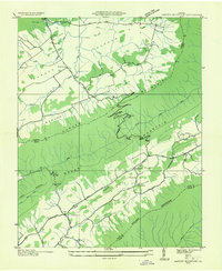
1935 Map of Garden Mountain
USGS Topo · Published 1935About this map
Burkes Garden Valley forms a unique geological bowl in the Appalachian Mountains, centered around small rural communities like Little Town and Burkes Garden. In the mid-1930s, this area was characterized by a distinct network of mountain gaps and valley floors, where Spring Creek and Snyder Branch drain the highland basin. The map reveals the local infrastructure of the era, including Central Ch and the winding Medley Pike. To the south, the terrain drops into Foglesong Valley, where the North Fork Holston River begins its course. Settlement patterns are concentrated along the river and at crossroad hamlets such as Ceres and Sharon Springs, which served as local hubs for the surrounding farmsteads. The inclusion of Red Oak Sch and Red Oak Ch illustrates the distributed nature of community life during this period of Tennessee Valley Authority development.
Find a feature on this map
44 named features on this map. Tap any name to fly to it.
Don’t see what you’re looking for? This feature index may not catch every label — zoom into the map to look around manually.
Map Details
Editions of this 1935 Garden Mountain Map
This is the sole edition of this map. No revisions or reprints were ever made.
Other maps of this area

1887 · Pocahontas
USGS Topo · 1:125,000

1889 · Wytheville
USGS Topo · 1:125,000

1891 · Pocahontas
USGS Topo · 1:125,000

1892 · Wytheville
USGS Topo · 1:125,000

1894 · Pocahontas
USGS Topo · 1:125,000

1895 · Pocahontas
USGS Topo · 1:125,000

1930 · Speedwell
USGS Topo · 1:62,500

1935 · Nebo
USGS Topo · 1:24,000
1935 · Tiptop
USGS Topo · 1:24,000
1935 · Nye Cove
USGS Topo · 1:24,000