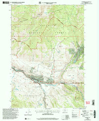
2000 Map of Gardiner
USGS Topo · Published 2005About this map
Gardiner serves as the focal point for this map, situated at the boundary where the Yellowstone River meets the Gardner River. The map captures the northern threshold of Yellowstone National Park, specifically the North Entrance, and the surrounding Gallatin National Forest. To the northeast, the settlement of Jardine is documented near active prospects and quarries, indicating the area's history of mineral extraction.
Find a feature on this map
52 named features on this map. Tap any name to fly to it.
Don’t see what you’re looking for? This feature index may not catch every label — zoom into the map to look around manually.
Map Details
Editions of this 2000 Gardiner Map
This is the sole edition of this map. No revisions or reprints were ever made.
Other maps of this area

1885 · Gallatin
USGS Topo · 1:125,000

1885 · Gallatin
USGS Topo · 1:125,000

1891 · Livingston
USGS Topo · 1:250,000

1893 · Livingston
USGS Topo · 1:250,000

1901 · Gallatin
USGS Topo · 1:125,000

1908 · Gallatin
USGS Topo · 1:125,000

1911 · Gallatin
USGS Topo · 1:125,000

1947 · Bozeman
USGS Topo · 1:250,000

1948 · Bozeman
USGS Topo · 1:250,000

1955 · Bozeman
USGS Topo · 1:250,000