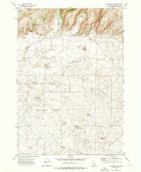
1972 Map of Gardner Lake
USGS Topo · Published 1976About this map
The U S Sheep Experiment Station dominates the southern half of this landscape, reflecting a unique era of agricultural research in Clark County. Established long before this 1971 aerial survey, the station features an intricate network of wells and water infrastructure, including a Water Tank, necessary for managing livestock in this semi-arid high country. To the north, the terrain transitions into a series of steep drainages, where the East Fork Corral Creek and West Fork Corral Creek converge near Gardner Lake. Evidence of small-scale resource exploration is visible at a marked Prospect near a Spring in the northwest corner, while Rattlesnake Creek carves through the central hills. The map highlights the reliance on dispersed water sources, from Threemile Reservoir to isolated springs, which dictated the movement of both sheep and early settlers.
Find a feature on this map
13 named features on this map. Tap any name to fly to it.
Don’t see what you’re looking for? This feature index may not catch every label — zoom into the map to look around manually.
Map Details
Editions of this 1972 Gardner Lake Map
This is the sole edition of this map. No revisions or reprints were ever made.
Other maps of this area

1955 · Dubois
USGS Topo · 1:250,000

1955 · Ashton
USGS Topo · 1:250,000

1958 · Dubois
USGS Topo · 1:250,000

1958 · Ashton
USGS Topo · 1:250,000

1960 · Ashton
USGS Topo · 1:250,000

1964 · Dubois NW
USGS Topo · 1:24,000

1964 · Dubois NE
USGS Topo · 1:24,000

1972 · Spencer South
USGS Topo · 1:24,000

1972 · Kilgore
USGS Topo · 1:24,000

1972 · Spencer North
USGS Topo · 1:24,000