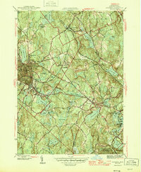
1946 Map of Gardner
USGS Topo · Published 1946About this map
The manufacturing and industrial hub of Gardner anchors this mid-century survey, showcasing a dense network of residential streets and civic institutions such as the Heywood Memorial Hospital. The Boston and Maine RR serves as a central artery for the region, threading through South Gardner and past numerous reservoirs that supported local industry and municipal needs. To the east, Westminster and the smaller settlements of Whitmanville and Bakers Grove are depicted amidst a landscape defined by significant water bodies like Wyman Pond and Meetinghouse Pond. The map captures the transition from the built environment of the furniture city to the protected lands of the Wachusett Mountain State Reservation in the southeast. Numerous named hills, including Barber Hill and Academy Hill, define the topography, while landmarks like the State Hospital and Mt Pleasant Cem provide essential data points for local historians and genealogists.
Find a feature on this map
66 named features on this map. Tap any name to fly to it.
Don’t see what you’re looking for? This feature index may not catch every label — zoom into the map to look around manually.
Map Details
Editions of this 1946 Gardner Map
2 editions found
Other maps of this area

1885 · Worcester
USGS Topo · 1:62,500

1886 · Worcester
USGS Topo · 1:62,500

1887 · Winchendon
USGS Topo · 1:62,500

1887 · Barre
USGS Topo · 1:62,500

1887 · Fitchburg
USGS Topo · 1:62,500

1889 · Fitchburg
USGS Topo · 1:62,500

1889 · Barre
USGS Topo · 1:62,500

1890 · Winchendon
USGS Topo · 1:62,500

1892 · Worcester
USGS Topo · 1:62,500

1893 · Fitchburg
USGS Topo · 1:62,500