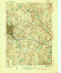
1946 Map of Gardner
USGS Topo · Published 1946About this map
The manufacturing center of Gardner is depicted during the mid-1940s, a period when the "Chair City" remained a bustling hub of industry and transport. The city's growth is anchored by the Boston and Maine RR, which snakes through the landscape to serve various industrial and civic sites, including the extensive grounds of the State Hospital and Heywood Memorial Hospital. The surrounding townships of Westminster and Ashburnham show a denser concentration of family-named hills like Barber Hill and Bean Porridge Hill, interspersed with countless ponds and reservoirs that supported the region's earlier mill economy.
Find a feature on this map
76 named features on this map. Tap any name to fly to it.
Don’t see what you’re looking for? This feature index may not catch every label — zoom into the map to look around manually.
Map Details
Editions of this 1946 Gardner Map
2 editions found
Other maps of this area

1885 · Worcester
USGS Topo · 1:62,500

1886 · Worcester
USGS Topo · 1:62,500

1887 · Winchendon
USGS Topo · 1:62,500

1887 · Barre
USGS Topo · 1:62,500

1887 · Fitchburg
USGS Topo · 1:62,500

1889 · Fitchburg
USGS Topo · 1:62,500

1889 · Barre
USGS Topo · 1:62,500

1890 · Winchendon
USGS Topo · 1:62,500

1892 · Worcester
USGS Topo · 1:62,500

1893 · Fitchburg
USGS Topo · 1:62,500