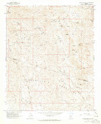
1964 Map of Garfias Mountain
USGS Topo · Published 1965About this map
Garfias Mountain rises above a landscape defined by industrial extraction and seasonal water sources along the border of Yavapai and Maricopa counties. During the mid-1960s, this area of the Buckhorn Mountains and Hieroglyphic Mountains was marked by active and historic mining operations, including the St Anthony Mine, the Morgan City Mine, and the Big Reef Mill. A network of rugged Jeep Trails and Pack Trails connected these remote sites to the Castle Hot Springs Road, which skirts the eastern edge of the quadrangle. Water, though scarce, was managed through a system of tanks and springs such as Layton Tank, Cedar Basin Tank, and Bitter Springs. The map also captures several family-named or local landmarks like L Ranch and the distinctive geological features of Big Hells Gate and Little Hells Gate, providing a detailed record of the mid-century cattle and mining economy in the Arizona desert.
Find a feature on this map
45 named features on this map. Tap any name to fly to it.
Don’t see what you’re looking for? This feature index may not catch every label — zoom into the map to look around manually.
Map Details
Editions of this 1964 Garfias Mountain Map
Other maps of this area

1887 · Prescott
USGS Topo · 1:250,000

1892 · Prescott
USGS Topo · 1:250,000

1903 · Bradshaw Mountains
USGS Topo · 1:125,000

1903 · Congress
USGS Topo · 1:125,000

1904 · Congress
USGS Topo · 1:125,000

1947 · Crown King
USGS Topo · 1:62,500

1947 · Wagoner
USGS Topo · 1:62,500

1948 · Crown King
USGS Topo · 1:63,360

1948 · Wagoner
USGS Topo · 1:63,360

1950 · Wagoner
USGS Topo · 1:62,500