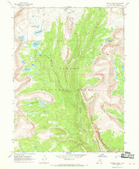
1967 Map of Garfield Basin
USGS Topo · Published 1969About this map
Ashley National Forest dominates this high-altitude landscape in the late 1960s, defined by a dense concentration of alpine water bodies and drainage basins. The Garfield Basin serves as a central hydrological hub, collecting water from Garfield Creek and surrounding peaks to feed into various named lakes including Five Point Lake, Gem Lake, and Doll Lake. This terrain, mapped via aerial photography in 1963 and field checked in 1967, highlights a wilderness infrastructure reliant on a primitive Pack Trail network rather than roads. To the south, Swasey Hole and the Swasey Lakes cluster show the glaciated character of the Duchesne County high country, where prominent passes like Tungsten Pass and Bluebell Pass provided the only traversable routes through the steep ridges separating the Yellowstone Creek and Milk Creek drainages.
Find a feature on this map
21 named features on this map. Tap any name to fly to it.
Don’t see what you’re looking for? This feature index may not catch every label — zoom into the map to look around manually.
Map Details
Editions of this 1967 Garfield Basin Map
2 editions found
Other maps of this area

1885 · Uinta
USGS Topo · 1:250,000

1901 · Hayden Peak
USGS Topo · 1:125,000

1903 · Hayden Peak
USGS Topo · 1:125,000

1905 · Gilbert Peak
USGS Topo · 1:125,000

1906 · Gilbert Peak
USGS Topo · 1:125,000

1954 · Salt Lake City
USGS Topo · 1:250,000

1958 · Salt Lake City
USGS Topo · 1:250,000

1960 · Salt Lake City
USGS Topo · 1:250,000

1965 · Mount Emmons
USGS Topo · 1:24,000
1965 · Kings Peak
USGS Topo · 1:24,000