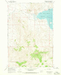
1965 Map of Garfield Canyon
USGS Topo · Published 1965About this map
Clark Canyon Reservoir dominates the eastern edge of this landscape, its waters meeting the rugged draws of Garfield Canyon and Limekiln Canyon. The map preserves the infrastructure of an earlier era with the Old Railroad Grade winding through the valley near Horse Prairie Creek, a corridor once vital for transport. Along the northwestern edge, Medicine Lodge Creek flows past the Peterson settlement and Paiment Ditch, illustrating early water management and ranching patterns. Miners and prospectors left their mark across the southern slopes, evidenced by several Prospect sites and a Gravel Pit near Indian Head. The terrain is crisscrossed by numerous Jeep Trails and Trails, connecting remote features like Johnson Gulch and Kissick Canyon to the recreation areas and campgrounds along the reservoir.
Find a feature on this map
29 named features on this map. Tap any name to fly to it.
Don’t see what you’re looking for? This feature index may not catch every label — zoom into the map to look around manually.
Map Details
Editions of this 1965 Garfield Canyon Map
This is the sole edition of this map. No revisions or reprints were ever made.
Other maps of this area

1893 · Dillon
USGS Topo · 1:250,000
1952 · Eli Spring
USGS Topo · 1:24,000
1952 · Dalys
USGS Topo · 1:24,000

1955 · Dubois
USGS Topo · 1:250,000

1955 · Dillon
USGS Topo · 1:250,000

1957 · Dillon
USGS Topo · 1:250,000

1958 · Dubois
USGS Topo · 1:250,000

1958 · Dillon
USGS Topo · 1:250,000
1959 · Grant
USGS Topo · 1:62,500

1962 · Dillon
USGS Topo · 1:250,000