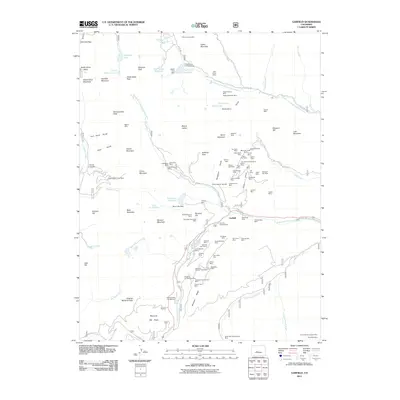
2011 Map of Garfield
USGS Topo · Published 2011About this map
High-altitude mining claims and rugged mountain passes dominate this 2011 survey of the Sawatch Range. The settlement of Garfield sits at the base of a dense cluster of historic workings on the eastern slopes of Taylor Mountain, including the Jewell Tunnel Mine, Mountain Chief Mine, and Last Chance Mine. This concentration of labels reflects the area's deep roots in the extraction industry, contrasted with the modern recreational footprint of the Monarch Ski Area near the southern boundary. Steep terrain is navigated via routes like Original Monarch Pass and Hancock Pass, while the high basins hold numerous alpine water bodies such as Hunkydory Lake and Hancock Lake. These drainage patterns feed into the South Arkansas River and the Middle Fork South Arkansas River, defining the local hydrology. For genealogists, the Tomichi Cemetery provides a rare and significant link to the early inhabitants who worked these remote mountain claims.
Find a feature on this map
114 named features on this map. Tap any name to fly to it.
Don’t see what you’re looking for? This feature index may not catch every label — zoom into the map to look around manually.
Map Details
Editions of this 2011 Garfield Map
This is the sole edition of this map. No revisions or reprints were ever made.
Other maps of this area

1940 · Garfield
USGS Topo · 1:62,500

1945 · Garfield
USGS Topo · 1:62,500

1956 · Poncha Springs
USGS Topo · 1:62,500

1956 · Montrose
USGS Topo · 1:250,000

1959 · Montrose
USGS Topo · 1:250,000

1959 · Bonanza
USGS Topo · 1:62,500

1960 · Montrose
USGS Topo · 1:250,000

1964 · Sargents
USGS Topo · 1:24,000

1967 · Pahlone Peak
USGS Topo · 1:24,000

1968 · Montrose
USGS Topo · 1:250,000