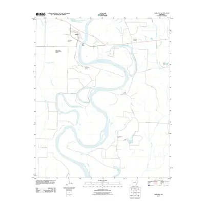
2011 Map of Garland
USGS Topo · Published 2011About this map
The Red River dominates this portion of Miller County, carving a serpentine path through a landscape defined by oxbow lakes and alluvial basins. The settlement of Garland is situated in the north, serving as a focal point near the Red River Bridge and Cypress City Lake. This 2011 survey reveals an environment where industrial activity and rural life coexist, evidenced by the Cypress Lake Oil and Gas Field and the Spirit Lake Oil and Gas Field positioned among family landmarks and small airfields. Notable locations for local historians include the Cedar Grove School and the Wright Cemetery, alongside numerous water bodies like Spirit Lake, Keller Lake, and Swan Lake that trace the river's ancient migrations across the floodplain. The inclusion of the Bill Rogers Airport and Reed-Joseph Land Company Airport highlights the logistical importance of aviation in this riverine region.
Find a feature on this map
34 named features on this map. Tap any name to fly to it.
Don’t see what you’re looking for? This feature index may not catch every label — zoom into the map to look around manually.
Map Details
Editions of this 2011 Garland Map
This is the sole edition of this map. No revisions or reprints were ever made.
Other maps of this area

1952 · Garland
USGS Topo · 1:24,000

1952 · Fouke SE
USGS Topo · 1:24,000

1952 · Bradley NE
USGS Topo · 1:24,000

1952 · Old Town
USGS Topo · 1:24,000

1952 · Doddridge NE
USGS Topo · 1:24,000

1952 · Canfield
USGS Topo · 1:24,000

1952 · Lewisville
USGS Topo · 1:24,000

1952 · Fouke NE
USGS Topo · 1:24,000

1952 · Boyd Hill
USGS Topo · 1:24,000

1953 · El Dorado
USGS Topo · 1:250,000