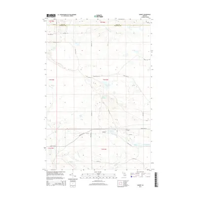
2014 Map of Garnet
USGS Topo · Published 2014About this map
Garnet sits as the central point of interest in this Garfield Township region of Mackinac County, serving as a hub for local roads like Park Rd and Hiawatha Trail Rd. This portion of the Upper Peninsula is defined by its complex hydrology, where the East Br Sage River and Black River drain a landscape dominated by wetlands and glacial lakes. Local history is anchored at the Maplewood Cem, located just east of the settlement near Garnet Lake. The map reveals a network of logging and transport routes, including the McLead Truck Trl and Giddings Truck Trl, which navigate between prominent water features such as Big Dollar Lake and the expanse of Kings Marsh. These roads and trails reflect the persistent use of the forest and wetland resources that have long shaped the local economy and settlement patterns.
Find a feature on this map
39 named features on this map. Tap any name to fly to it.
Don’t see what you’re looking for? This feature index may not catch every label — zoom into the map to look around manually.
Map Details
Editions of this 2014 Garnet Map
This is the sole edition of this map. No revisions or reprints were ever made.
Other maps of this area
1931 · Epoufette NW
USGS Topo · 1:31,680
1931 · Epoufette SW
USGS Topo · 1:31,680
1931 · Gilchrist NE
USGS Topo · 1:31,680
1931 · Gilchrist NW
USGS Topo · 1:31,680
1951 · Hulbert
USGS Topo · 1:24,000
1951 · Eckerman
USGS Topo · 1:62,500
1954 · Sault Sainte Marie
USGS Topo · 1:250,000
1956 · Sault Sainte Marie
USGS Topo · 1:250,000
1957 · Sault Sainte Marie
USGS Topo · 1:250,000
1958 · Sault Sainte Marie
USGS Topo · 1:250,000