
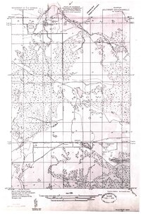
1931 Map of Gilchrist NE
USGS Topo · Published 1931About this map
The Minneapolis St Paul and Sault Ste Marie railroad cuts a decisive horizontal line across this Upper Peninsula landscape, connecting the settlement of Garnet to the wider region. In the early 1930s, this area of Mackinac County was defined by its extractive industries and natural water systems, with the Hendricks Quarry situated near the Luce County line and a prominent Fire Tower standing watch over the timberlands to the north. The southern portion of the quadrangle shows a concentrated pocket of activity near Garnet Lake, including the Maplewood Cem and a nearby Gravel Pit. Drainage is dominated by the Black River in the west and the Sage River in the east, while interior wetlands like Kings Marsh and clusters such as Seven Lakes illustrate the difficult, water-logged terrain that dictated the placement of State Highway No 2.
Find a feature on this map
20 named features on this map. Tap any name to fly to it.
Don’t see what you’re looking for? This feature index may not catch every label — zoom into the map to look around manually.
Map Details
Editions of this 1931 Gilchrist NE Map
2 editions found
Other maps of this area

1931 · Epoufette NW
USGS Topo · 1:31,680

1931 · Epoufette SW
USGS Topo · 1:31,680

1931 · Gilchrist NW
USGS Topo · 1:31,680

1951 · Hulbert
USGS Topo · 1:24,000

1951 · Eckerman
USGS Topo · 1:62,500

1954 · Sault Sainte Marie
USGS Topo · 1:250,000

1956 · Sault Sainte Marie
USGS Topo · 1:250,000

1957 · Sault Sainte Marie
USGS Topo · 1:250,000

1958 · Sault Sainte Marie
USGS Topo · 1:250,000
1964 · Epoufette
USGS Topo · 1:24,000