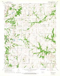
1966 Map of Garnett SE
USGS Topo · Published 1967About this map
Greeley anchors the northwestern corner of this landscape, where the confluence of the natural environment and local industry is evident through numerous Oil Wells and a local Quarry. The terrain is defined by the winding paths of Middle Creek and Landers Creek, which cut through the townships of Walker, Liberty, and Union. This 1966 field-checked survey reveals a rural infrastructure centered on established family and community landmarks, including the Wait Cem and Sutton Valley Cem.
Find a feature on this map
14 named features on this map. Tap any name to fly to it.
Don’t see what you’re looking for? This feature index may not catch every label — zoom into the map to look around manually.
Map Details
Editions of this 1966 Garnett SE Map
2 editions found
Other maps of this area

1885 · Garnett
USGS Topo · 1:125,000

1887 · Mound City
USGS Topo · 1:125,000

1893 · Mound City
USGS Topo · 1:125,000

1894 · Garnett
USGS Topo · 1:125,000

1947 · Lawrence
USGS Topo · 1:250,000

1950 · Lawrence
USGS Topo · 1:250,000

1956 · Lawrence
USGS Topo · 1:250,000

1961 · Lawrence
USGS Topo · 1:250,000

1963 · Parker
USGS Topo · 1:24,000
1963 · Osawatomie
USGS Topo · 1:24,000