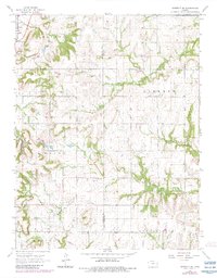
1966 Map of Garnett SE
USGS Topo · Published 1983About this map
Greeley sits at the northwestern corner of this Anderson County landscape, where the local economy in the mid-1960s is defined by a mix of agricultural land and early industrial extraction. Small clusters of Oil Wells and a Quarry indicate the area's resource-based activity, while the rural interior is organized by established townships including Walker, Liberty, and Union. The terrain is drained by the winding paths of Middle Creek and Landers Creek, with the Wait Dam and Sutton Valley Cem serving as significant local landmarks for genealogists and local historians. This survey, updated with 1980s revisions, illustrates a transition between traditional farming and modern infrastructure along the Anderson and Linn County line, capturing the spatial layout of rural Kansas before significant 20th-century consolidation.
Find a feature on this map
14 named features on this map. Tap any name to fly to it.
Don’t see what you’re looking for? This feature index may not catch every label — zoom into the map to look around manually.
Map Details
Editions of this 1966 Garnett SE Map
2 editions found
Other maps of this area

1885 · Garnett
USGS Topo · 1:125,000

1887 · Mound City
USGS Topo · 1:125,000

1893 · Mound City
USGS Topo · 1:125,000

1894 · Garnett
USGS Topo · 1:125,000

1947 · Lawrence
USGS Topo · 1:250,000

1950 · Lawrence
USGS Topo · 1:250,000

1956 · Lawrence
USGS Topo · 1:250,000

1961 · Lawrence
USGS Topo · 1:250,000

1963 · Parker
USGS Topo · 1:24,000
1963 · Osawatomie
USGS Topo · 1:24,000