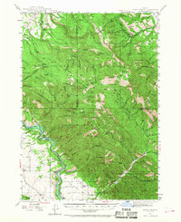
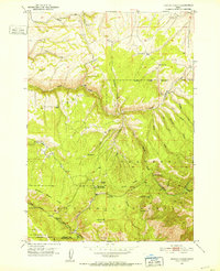
1943 Map of Garns Mtn
USGS Topo · Published 1968About this map
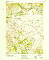
The Snake River curves through the southwestern corner of this Idaho landscape, where high-altitude ranching and mining define the local economy during the mid-1940s. Established operations like the Idaho Mine, Brown Bear Mine, and Amikesell Mine are situated in the northern reaches, while agricultural life is represented by the Durrant Ranch and Galli Ranch located near the riverbank. This map illustrates the transition from the level terrain of Antelope Flat and Lufkin Bottom into the steep ridges of the Targhee National Forest. Local infrastructure is anchored by the Upper Pine Creek Sch, serving the scattered homesteads and settlements of this mountainous region. Prominent peaks such as Garns Mtn and Piney Pk provide a detailed topographic survey of the Snake River Range, showing the drainage patterns of canyons like Calamity Creek and Moody Creek.
Find a feature on this map
105 named features on this map. Tap any name to fly to it.
Don’t see what you’re looking for? This feature index may not catch every label — zoom into the map to look around manually.
Map Details
Editions of this 1943 Garns Mtn Map
3 editions found

Other maps of this area

1924 · Hell Creek
USGS Topo · 1:62,500

1926 · Hell Creek
USGS Topo · 1:62,500

1932 · Irwin
USGS Topo · 1:96,000

1935 · Irwin
USGS Topo · 1:125,000
1943 · Driggs
USGS Topo · 1:62,500
1943 · Garns Mtn
USGS Topo · 1:62,500
1946 · Driggs
USGS Topo · 1:62,500

1946 · Garns Mtn
USGS Topo · 1:62,500
1951 · Hawley Gulch
USGS Topo · 1:24,000
1951 · Heise SE
USGS Topo · 1:24,000