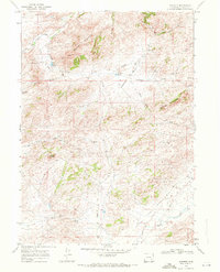
1968 Map of Garrett
USGS Topo · Published 1972About this map
The confluence of the Laramie River and the North Laramie River anchors this 1968 topographic study of northern Albany County. The landscape is defined by the high elevations of Sellers Mountain and Brandel Mountain, where early industrial attempts are marked by several Prospects and the distinct location of Asbestos Spring. Water management for ranching and transport is evident through a series of named reservoirs, including Sturgeon Res No 1, Sturgeon Res No 2, and Sturgeon Res No 3.
Find a feature on this map
30 named features on this map. Tap any name to fly to it.
Don’t see what you’re looking for? This feature index may not catch every label — zoom into the map to look around manually.
Map Details
Editions of this 1968 Garrett Map
This is the sole edition of this map. No revisions or reprints were ever made.
Other maps of this area

1954 · Torrington
USGS Topo · 1:250,000

1954 · Cheyenne
USGS Topo · 1:250,000

1955 · Dodge Ranch
USGS Topo · 1:24,000

1955 · Ayres Spring
USGS Topo · 1:24,000

1955 · Bull Camp Peak
USGS Topo · 1:24,000

1958 · Cheyenne
USGS Topo · 1:250,000

1958 · Torrington
USGS Topo · 1:250,000

1968 · Cow Creek Mountain
USGS Topo · 1:24,000

1968 · Davidson Flats
USGS Topo · 1:24,000

1968 · Cottonwood Creek
USGS Topo · 1:24,000