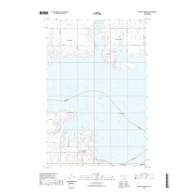
2020 Map of Garrison Dam North
USGS Topo · Published 2020About this map
Lake Sakakawea dominates this landscape where the Missouri River was transformed by the massive engineering of the mid-20th century. The intricate shoreline, defined by deep inlets like Garrison Bay and De Trobriand Bay, illustrates the complex topography created as the water rose against the high plains. On the southern banks, the planned layout of Pick City and the edge of Riverdale reflect the human history of the dam project, serving as hubs for workers and residents along the reservoir. Local residential development is evident in the street names of the Sakawea Estates Rd area, featuring roads like Apache Loop, Sioux Dr, and Arikara Ln. This survey captures the intersection of large-scale water management and the burgeoning recreational and residential footprint on the McLean and Mercer county line.
Find a feature on this map
23 named features on this map. Tap any name to fly to it.
Don’t see what you’re looking for? This feature index may not catch every label — zoom into the map to look around manually.
Map Details
Editions of this 2020 Garrison Dam North Map
This is the sole edition of this map. No revisions or reprints were ever made.
Other maps of this area

1922 · Garrison
USGS Topo · 1:62,500

1948 · Stanton
USGS Topo · 1:62,500

1949 · Stanton
USGS Topo · 1:62,500

1954 · McClusky
USGS Topo · 1:250,000

1956 · Emmet NE
USGS Topo · 1:24,000

1958 · McClusky
USGS Topo · 1:250,000

1967 · Emmet SE
USGS Topo · 1:24,000

1969 · Hazen NE
USGS Topo · 1:24,000
1969 · Garrison Dam South
USGS Topo · 1:24,000
1972 · Garrison Dam North
USGS Topo · 1:24,000