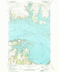
1972 Map of Garrison Dam North
USGS Topo · Published 1974About this map
Pick City sits at the southern edge of this mid-1970s landscape, serving as a gateway to the massive engineering works of the Dam on the Missouri River. The area is defined by the transformation of the Missouri valley into Lake Sakakawea, creating extensive recreation and conservation zones like Lake Sakakawea State Park and the De Trobriand State Game Management Area. This survey provides a record of land use following the reservoir's creation, highlighting the Old Fort Stevenson Military Reservation Boundary which cuts across the modern shoreline. Significant social and industrial infrastructure is documented, from the Camp Dominic Savio and NW North Dakota Girl Scout Camp to the Powerplant and Intake structures essential to the region's energy production. The Soo Line railroad passes through the northern reaches, while scoria pits hint at the local geology utilized during this era of development.
Find a feature on this map
29 named features on this map. Tap any name to fly to it.
Don’t see what you’re looking for? This feature index may not catch every label — zoom into the map to look around manually.
Map Details
Editions of this 1972 Garrison Dam North Map
This is the sole edition of this map. No revisions or reprints were ever made.
Other maps of this area

1922 · Garrison
USGS Topo · 1:62,500

1948 · Stanton
USGS Topo · 1:62,500

1949 · Stanton
USGS Topo · 1:62,500

1954 · McClusky
USGS Topo · 1:250,000

1956 · Emmet NE
USGS Topo · 1:24,000

1958 · McClusky
USGS Topo · 1:250,000

1967 · Emmet SE
USGS Topo · 1:24,000

1969 · Hazen NE
USGS Topo · 1:24,000
1969 · Garrison Dam South
USGS Topo · 1:24,000
1972 · Riverdale South
USGS Topo · 1:24,000