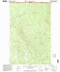
1997 Map of Garver Mountain
USGS Topo · Published 2000About this map
The northern edge of the Purcell Mountains meets the international boundary between the Canada United States border in this late-1990s revision. This remote section of the Kootenai National Forest is defined by the drainage systems of the West Fork Yaak River and Pete Creek, showing a landscape managed for both timber and recreation. The presence of the Pete Creek Camp and a Lookout atop Garver Mountain indicates the traditional forest service infrastructure used for fire management and backcountry access. Significant summits like Mount Obermayer and Mushroom Mountain overlook a network of forest roads, including specialized 4wd tracks, while a Gravel Pit near Beetle Creek suggests local maintenance activity in this high-elevation corridor of Lincoln County.
Find a feature on this map
22 named features on this map. Tap any name to fly to it.
Don’t see what you’re looking for? This feature index may not catch every label — zoom into the map to look around manually.
Map Details
Editions of this 1997 Garver Mountain Map
This is the sole edition of this map. No revisions or reprints were ever made.
Other maps of this area

1957 · Kalispell
USGS Topo · 1:250,000

1960 · Kalispell
USGS Topo · 1:250,000

1961 · Kalispell
USGS Topo · 1:250,000

1963 · Yaak
USGS Topo · 1:24,000

1963 · Mount Baldy
USGS Topo · 1:24,000

1963 · Northwest Peak
USGS Topo · 1:24,000

1963 · Garver Mountain
USGS Topo · 1:24,000

1963 · Clark Mountain
USGS Topo · 1:24,000

1963 · Bonnet Top
USGS Topo · 1:24,000

1979 · Yaak River
USGS Topo · 1:100,000