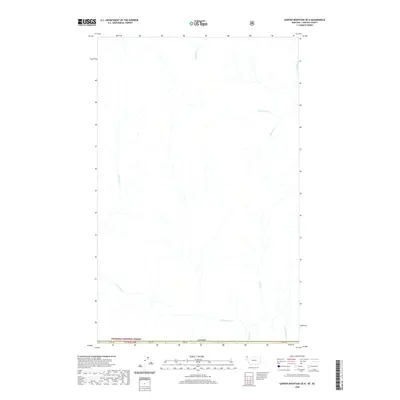
2020 Map of Garver Mountain OE N
USGS Topo · Published 2020About this map
The Yahk River drainage system dominates this high-latitude terrain along the international border in Lincoln County, Montana. The map details the remote northern reaches of the Kootenai National Forest where the river flows south toward the border crossing between Montana and British Columbia, Canada. This 2020 topographical study highlights the intricate network of alpine tributaries including Malpass Cr, Sprucetree Cr, and Brotten Cr. These water bodies define the drainage patterns of the region, providing a clear view of the natural hydrology of the Cabinet Mountains area before these waters reach more developed southern valleys. The lack of named roads or human structures emphasizes the wilderness character of this specific quadrant of the northern Rockies.
Find a feature on this map
4 named features on this map. Tap any name to fly to it.
Don’t see what you’re looking for? This feature index may not catch every label — zoom into the map to look around manually.
Map Details
Editions of this 2020 Garver Mountain OE N Map
This is the sole edition of this map. No revisions or reprints were ever made.
Other maps of this area

1957 · Kalispell
USGS Topo · 1:250,000

1960 · Kalispell
USGS Topo · 1:250,000

1961 · Kalispell
USGS Topo · 1:250,000

1963 · Northwest Peak
USGS Topo · 1:24,000

1963 · Garver Mountain
USGS Topo · 1:24,000

1963 · Bonnet Top
USGS Topo · 1:24,000

1979 · Yaak River
USGS Topo · 1:100,000
1997 · Bonnet Top
USGS Topo · 1:24,000
1997 · Garver Mountain
USGS Topo · 1:24,000
1997 · Northwest Peak
USGS Topo · 1:24,000