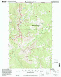
1997 Map of Northwest Peak
USGS Topo · Published 2000About this map
Northwest Peak and the high alpine ridges of the Kaniksu National Forest dominate this 1997 revision of the Lincoln County high country. Situated directly on the border between the United States and Canada, this terrain is defined by a dense network of drainages and glacial lakes. Headwaters for Hawkins Creek, Spread Creek, and the Yaak River carve deep valleys through the mountains, while high-altitude water bodies like Burke Lake, Lake Florence, and Hawkins Lakes sit in the shadows of prominent summits such as Davis Mountain and Rock Candy Mountain. The map illustrates a strictly managed wilderness, showing the intersection of the Bonners Ferry Ranger District and the Three Rivers Ranger District. This intersection highlights how forest management and international boundaries have preserved the primitive character of the Kootenai National Forest into the late 20th century.
Find a feature on this map
33 named features on this map. Tap any name to fly to it.
Don’t see what you’re looking for? This feature index may not catch every label — zoom into the map to look around manually.
Map Details
Editions of this 1997 Northwest Peak Map
This is the sole edition of this map. No revisions or reprints were ever made.
Other maps of this area

1911 · Priest Lake
USGS Topo · 1:250,000

1913 · Priest Lake
USGS Topo · 1:250,000

1957 · Kalispell
USGS Topo · 1:250,000

1958 · Sandpoint
USGS Topo · 1:250,000

1960 · Kalispell
USGS Topo · 1:250,000

1961 · Kalispell
USGS Topo · 1:250,000

1963 · Sandpoint
USGS Topo · 1:250,000

1963 · Mount Baldy
USGS Topo · 1:24,000

1963 · Northwest Peak
USGS Topo · 1:24,000

1963 · Garver Mountain
USGS Topo · 1:24,000