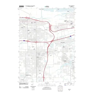
2011 Map of Gary
USGS Topo · Published 2011About this map
Lake Michigan dominates the northern horizon of this industrial corridor, where the Grand Calumet River and Little Calumet River wind through the urban grid of Gary. This 2011 survey reveals a landscape of established neighborhoods like Tolleston, Aetna, and Glen Park, punctuated by institutional landmarks such as Indiana University Northwest. The area is characterized by an extensive network of specialized postal stations, including the Gary Main Post Office and Miller Station Gary Post Office, reflecting the city's complex logistics and history.
Find a feature on this map
56 named features on this map. Tap any name to fly to it.
Don’t see what you’re looking for? This feature index may not catch every label — zoom into the map to look around manually.
Map Details
Editions of this 2011 Gary Map
This is the sole edition of this map. No revisions or reprints were ever made.
Other maps of this area

1900 · Toleston
USGS Topo · 1:62,500

1934 · Porter
USGS Topo · 1:48,000

1940 · Porter
USGS Topo · 1:62,500

1953 · St. John
USGS Topo · 1:24,000

1953 · Palmer
USGS Topo · 1:24,000

1953 · Gary
USGS Topo · 1:24,000

1953 · Crown Point
USGS Topo · 1:24,000
1953 · Whiting
USGS Topo · 1:24,000

1953 · Garyton
USGS Topo · 1:24,000

1953 · Ogden Dunes
USGS Topo · 1:24,000