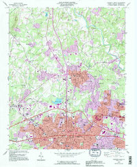
1993 Map of Gastonia North
USGS Topo · Published 1996About this map
Gastonia and its northern suburbs are captured here during a period of significant urban growth, with 1993 revisions showing expanding residential footprints in purple against the established industrial and civic core. The map documents the city's institutional landscape, from the Schiele Museum and the State Orthopedic Hosp to numerous local schools like Ashley High Sch. Beyond the city limits, the terrain transitions into a mix of small settlements and natural landmarks, including the heights of Pasour Mountain and the waters of Rankin Lake.
Find a feature on this map
78 named features on this map. Tap any name to fly to it.
Don’t see what you’re looking for? This feature index may not catch every label — zoom into the map to look around manually.
Map Details
Editions of this 1993 Gastonia North Map
This is the sole edition of this map. No revisions or reprints were ever made.
Other maps of this area

1906 · Kings Mountain
USGS Topo · 1:62,500

1908 · Kings Mountain
USGS Topo · 1:62,500

1909 · Lincolnton
USGS Topo · 1:62,500

1911 · Lincolnton
USGS Topo · 1:62,500

1914 · Gastonia
USGS Topo · 1:48,000

1916 · Gastonia
USGS Topo · 1:62,500

1947 · Clover
USGS Topo · 1:62,500

1949 · Clover
USGS Topo · 1:62,500

1953 · Charlotte
USGS Topo · 1:250,000

1954 · Charlotte
USGS Topo · 1:250,000