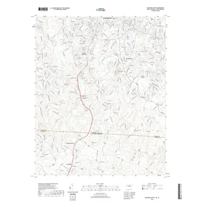
2019 Map of Gastonia South
USGS Topo · Published 2019About this map
Gastonia and South Gastonia serve as the northern anchors of this 2019 survey, which documents the residential and industrial corridors extending south toward the North Carolina South Carolina border. The landscape is defined by the headwaters and tributaries of Crowders Creek, including S Fork Crowders Cr and Beaverdam Cr, which drain the undulating terrain near Jackson Knob. Genealogists will find a wealth of local landmarks, from established burial grounds like Olney Church Cem and Firestone Cem to smaller rural sites like Mount Pleasant Church Cem. The map captures a mix of longstanding communities such as Crowders, Boogertown, and Bowling Green, alongside the aviation facilities of the Gastonia Municipal Airport. In the southern portion of the sheet, the town of Clover appears just across the state line, illustrating the cross-border connectivity of this Piedmont region.
Find a feature on this map
276 named features on this map. Tap any name to fly to it.
Don’t see what you’re looking for? This feature index may not catch every label — zoom into the map to look around manually.
Map Details
Editions of this 2019 Gastonia South Map
This is the sole edition of this map. No revisions or reprints were ever made.
Other maps of this area

1906 · Kings Mountain
USGS Topo · 1:62,500

1908 · Kings Mountain
USGS Topo · 1:62,500

1909 · Lincolnton
USGS Topo · 1:62,500

1911 · Lincolnton
USGS Topo · 1:62,500

1914 · Gastonia
USGS Topo · 1:48,000

1916 · Gastonia
USGS Topo · 1:62,500

1947 · Clover
USGS Topo · 1:62,500

1949 · Clover
USGS Topo · 1:62,500

1953 · Charlotte
USGS Topo · 1:250,000

1954 · Charlotte
USGS Topo · 1:250,000